Life-Cycle Monitoring for CO2 Site Analysis and Daily Plume Mapping
Our team offers an all-encompassing monitoring service for CO2 site analysis and plume mapping to aid our clients in mitigating seismic risks and meeting regulatory requirements. We use low-cost, high-impact seismic monitoring networks to analyze potential CO2 injection sites. During injection, our unique, remotely operated seismic sources are coupled with the same sensors to map plume migration every day. These sensors remain active and continue to record seismic activity for decades to come.
Before Injection

Assessing Candidate Sites for CO2 Injection
Before any CO2 injection can take place, it’s crucial to characterize and evaluate each potential site for its aptness as a permanent storage site. One integral process is to track the natural background seismic noise, ensuring there are no natural Earth movements. This allows operators to identify active faults in the area and establish a fundamental baseline for continuous monitoring during and after injection.
During and After Injection

Monitoring CO2 Injection to Ensure Safe Storage
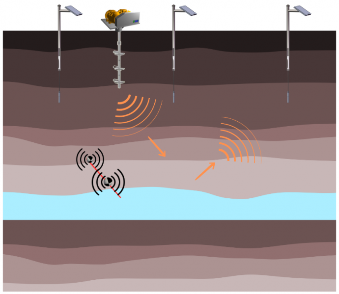
When CO2 is injected into a depleted reservoir or saline aquifer, it’s crucial to monitor the response to the injection. Our sensors are designed to continually measure induced seismic activity, which could signal a containment breach, and actively monitor the pressure front. Our permanent seismic sources are solar-powered and operate daily to track changes in seismic reflections, revealing the spatial migration of the plume in the reservoir.
CO2 Plume Migration
On-Demand Seismic Surveys with Permanent Sources and IoT Receivers
Our team has developed a cost-effective solution to perform daily seismic surveys. By combining our unique low-cost permanent linear vibratory source (SLV) with a network of affordable receivers, we can record seismic data quickly and efficiently. The system is designed with fixed sources and receivers that are remotely operated. The only dynamic change is the movement of the injected CO2 plume. Regular analysis of the seismic reflection at the same depth point allows us to map the plume. This is because the seismic reflection changes as the plume migrates through the depth point.